


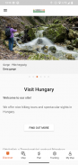

Természetjáró, a túratervező
Περιγραφή του Természetjáró, a túratervező
Ο διαδικτυακός τουριστικός οδηγός της Ουγγαρίας, ειδικά σχεδιασμένος για πεζοπόρους, ποδηλάτες, trailrunner, ορειβάτες και λάτρεις των θαλάσσιων σπορ, με ενσωματωμένο τουριστικό προγραμματιστή, καθώς και εκατοντάδες προτεινόμενες εκδρομές και χιλιάδες αξιοθέατα, όλα με λεπτομερείς περιγραφές και πολλές φωτογραφίες , με άνεση σε διαδραστικό χάρτη. Διατίθεται δωρεάν, με δυνατότητα συνδρομής για εκτεταμένη λειτουργικότητα.
Δυνατότητες
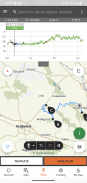
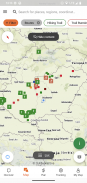
• Διάφοροι διαδραστικοί, με δυνατότητα μεγέθυνσης, διανυσματικά χάρτες πεζοπορίας σε όλο τον κόσμο με όλα τα σημαδεμένα μονοπάτια, που δείχνουν την τρέχουσα θέση σας
• Ένας βολικός τρόπος για να προγραμματίσετε τη δική σας περιήγηση στο χάρτη και να λάβετε αμέσως προφίλ διάρκειας, διάρκειας και υψομέτρου
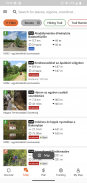
• Περισσότερες από χίλιες προτεινόμενες εκδρομές για πεζοπόρους, ποδηλάτες, δρομείς μονοπατιών και κανό, με πρακτικά δεδομένα, λεπτομερή περιγραφή των καλύτερων κοντινών αξιοθέατων, φυσικό και πολιτιστικό υπόβαθρο, φωτογραφίες καλής ποιότητας και πληροφορίες για το πώς θα φτάσετε εκεί
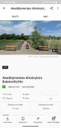
• Χιλιάδες προτεινόμενα αξιοθέατα στην Ουγγαρία, όπως πύργοι επιφυλακής, φυσικά πανοραμικά σημεία, δασικά τρένα, φρούρια και μουσεία, με λεπτομερή περιγραφή, φωτογραφίες καλής ποιότητας, καθώς και πληροφορίες για το πώς θα φτάσετε εκεί
• Εκατοντάδες καταλύματα, συμπεριλαμβανομένων καλύβων, τουριστικών ξενοδοχείων και διαμερισμάτων, κοντά σε σημαδεμένα μονοπάτια
• Χρήσιμες συλλογές με προβολή χάρτη: παραλίες γύρω από τη λίμνη Balaton, αρένες για πατινάζ στον πάγο, βοτανικοί κήποι, οι καλύτερες διαδρομές τρεξίματος, μέρη για αναρρίχηση βράχου, εκδρομές για άτομα με αναπηρία κ.λπ.
• Ειδοποιήσεις, προειδοποιήσεις και κλεισίματα
• Λήψη ενοτήτων χάρτη, περιηγήσεων και αξιοθέατων για χρήση εκτός σύνδεσης
• On the fly πλοήγηση κατά μήκος της διαδρομής με ζωντανό προφίλ υψομέτρου και φωνητικές οδηγίες
• Καταγράψτε τη διαδρομή σας
• BuddyBeacon: μοιραστείτε τη θέση σας με φίλους ζωντανά
• Ολόκληρη η Γαλάζια περιήγηση στην Ουγγαρία, με επίσημα τμήματα και διαδρομή, POI και καταλύματα
• Συγχρονίστε όλο το περιεχόμενό σας μεταξύ υπολογιστή και φορητών συσκευών που εκτελούν την εφαρμογή
• Ελέγξτε την τοπική πρόγνωση καιρού
• 3D-flight: μια εικονική πανοραμική άποψη της περιήγησης
• Χρήσιμα εργαλεία ενσωματωμένα, όπως peak finder(Skyline) και πυξίδα με την τρέχουσα θέση σας
• Υπηρεσίες κοινότητας: βαθμολογήστε και μοιραστείτε περιεχόμενο με τους φίλους σας
Έξυπνα ρολόγια με WEAR OS από την Google
Με μια ματιά στο Smartwatch σας, λαμβάνετε πληροφορίες σχετικά με τη θέση σας στο GPS στο χάρτη. Μπορείτε να καταγράψετε κομμάτια, να λάβετε δεδομένα παρακολούθησης και να πλοηγηθείτε σε διαδρομές. Χρησιμοποιήστε το πλακίδιο της εφαρμογής για εύκολη πρόσβαση σε κοντινές διαδρομές.
Αποκλειστικά για Pro μέλη
Πηγαίνετε οπουδήποτε: Το Outdooractive Pro λειτουργεί εκτός σύνδεσης χωρίς σήματα κινητής τηλεφωνίας και δεδομένων. Μπορούν επίσης να δημιουργηθούν απεριόριστες λίστες και η εφαρμογή είναι χωρίς διαφημίσεις. Επιπλέον, μπορείτε να δείτε δορυφορικές εικόνες, τον μοναδικό χάρτη Outdooractive με πάνω από 30 δίκτυα μονοπατιών δραστηριοτήτων και επίσημους τοπογραφικούς χάρτες από τους ακόλουθους παρόχους:
Great Britain Ordnance Survey, Landranger, Explorer
Πληροφορίες γης Νέας Ζηλανδίας
Γιούτα USGS
Γερμανία BKG
Αυστρία BEV
Ελβετία swisstopo
Γαλλία IGN
Ισπανία CNIG
Ιταλία
Ολλανδία PDOK
Νορβηγία Kartverket
Δανία Kortforsyningen
Σουηδία Lantmäteriet
Εθνική Έρευνα Γης της Φινλανδίας
Ιαπωνία GSI
ΠΑΓΚΟΣΜΙΟΣ ΧΑΡΤΗΣ
Αποκλειστικά για μέλη Pro+
Το Pro+ περιέχει επίσης επίσημους χάρτες από Alpine Associations καθώς και premium χάρτες από την KOMPASS.
Εάν έχετε ερωτήσεις ή προτάσεις, επισκεφτείτε τη διεύθυνση
https://www.termeszetjaro.hu/hu/p/gyakran-ismetelt-kerdesek/41050512 /
Η έκδοση για υπολογιστές μας:
https://www.termeszetjaro.hu/
Ακολουθήστε μας στο Facebook:
https://www.facebook.com/Termeszetjaro.hu/
Επικοινωνήστε μαζί μας:
termeszetjaro@termeszetjaro.hu
Περισσότερα για την κάρτα TEKA:
http://www.termeszetjarokartya.hu/
Természetjáró, a túratervező - Πληροφορίες APK
Έκδοση APK: 3.19.4Πακέτο: com.outdooractive.mtszΤελευταία έκδοση του Természetjáró, a túratervező
Άλλες εκδόσεις


Εφαρμογές στην ίδια κατηγορία

Μπορεί επίσης να σου αρέσουν...


